What the Teesta Actually Needs: AI, Satellites, and the Treaty That Technology Makes Possible
On the night of June 25, 2026, while most of South Asia slept, a brief announcement crossed the wires from Beijing. Bangladesh's Prime Minister Tarique Rahman and China's Water Resources Minister Li Guoying had agreed to deepen cooperation on river management, specifically including the Teesta River Comprehensive Management and Restoration Project. The latest agreement does not address the unresolved Teesta water-sharing treaty between the two neighbours. Negotiations on that issue have remained stalled for more than a decade


What the Teesta Actually Needs: AI, Satellites, and the Treaty That Technology Makes Possible
On the night of June 25, 2026, while most of South Asia slept, a brief announcement crossed the wires from Beijing. Bangladesh's Prime Minister Tarique Rahman and China's Water Resources Minister Li Guoying had agreed to deepen cooperation on river management, specifically including the Teesta River Comprehensive Management and Restoration Project. The latest agreement does not address the unresolved Teesta water-sharing treaty between the two neighbours. Negotiations on that issue have remained stalled for more than a decade.
That detail is the whole story in one sentence. The river that India and Bangladesh have been trying to share for forty years remains unshared. The country that moved first was not either of them. It was China. There is a version of this moment that frames it as a strategic defeat, a betrayal, and a warning sign about India's eastern flank. That version is understandable and not entirely wrong. But it is incomplete. The more accurate framing begins not in Beijing but in the rice fields of Rangpur, where farmers have watched the Teesta shrink in the dry season and swell without warning in the monsoon for generations, waiting for two neighbours who share their river to agree on something before someone else decided for them. The Teesta problem is, at its foundation, a water-security and climate-vulnerability problem. The only durable solution lies in technology-enabled cooperation between India and Bangladesh, not in treating Bangladesh's development choices as a battlefield.
What the River Actually Carries
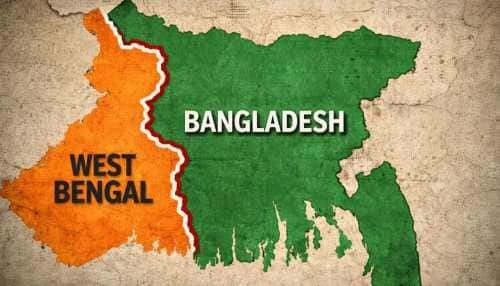
The Teesta is the fourth largest river in Bangladesh. It rises in Sikkim, flows through West Bengal, and enters Bangladesh's northern Rangpur division, where its floodplain spans 2,750 square kilometres. The river is essential for agriculture, food production, fishing, and domestic needs. It is vital for cultivating Boro rice, Bangladesh's largest crop, and irrigates about 14 percent of the total cropped area. The northern region, known as the country's granary, depends heavily on the river for irrigation.
The interconnectedness of this geography matters deeply for understanding why the problem has proved so stubborn. The Teesta does not just carry water. It carries sediment that builds soil. It carries snowmelt that arrives in spring when irrigation demand is highest. It carries flood risk in the monsoon when releases from upstream barrages arrive without sufficient warning. During the dry season, there is minimal water in the river due to upstream water diversion by India through the Gajoldoba barrage in West Bengal. Consequently, local farmers suffer from water shortages for irrigation, resulting in crop losses. However, with the onset of the monsoon, there is an unexpected release of water upstream, causing floods and river erosion. This dual jeopardy, drought in the dry season and flood risk in the monsoon, is the daily reality of millions of people in northern Bangladesh. Any solution to the Teesta problem that does not address both conditions simultaneously is not a solution. It is a postponement.
The History That Created This Moment
India and Bangladesh have tried to formalise sharing since at least 1983. A provisional arrangement that year designated 39 percent of the Teesta's waters to India, 36 percent to Bangladesh, and left 25 percent unallocated. In 2011, a proposal for a provisional agreement was presented, allocating 42.5 percent to India and 37.5 percent to Bangladesh. This project was abandoned due to significant opposition from the West Bengal government. The feedback loop this created has compounded over two decades. India delayed, citing domestic political constraints. Bangladesh waited, citing diplomatic patience. Each year of waiting deepened Bangladeshi frustration and created an opening for external actors to offer what the bilateral relationship could not.
Many Bangladeshis see the Teesta issue as a measure of the sincerity and effectiveness of regional cooperation between the two neighbouring countries. While Bangladesh has often addressed several of India's security concerns, particularly regarding insurgency and regional connectivity, many in Dhaka feel that Bangladesh's own water concerns have not received the same urgency or attention. Against this backdrop, China's willingness to support the Teesta project inevitably reshapes the diplomatic equation. During her visit to New Delhi in June 2024, former Prime Minister Sheikh Hasina welcomed an Indian proposal to undertake conservation and management work on the Teesta River, publicly indicating that she preferred India to execute the scheme, arguing that India controlled the upstream flow and was therefore better placed to address long-term water management issues. That window, briefly opened, closed with the political transition that followed in August 2024. The moment passed. The river did not stop flowing.
Why Alarmism Is the Wrong Response
The instinctive Indian response to the June 2026 Beijing announcement is to frame it in terms of strategic encirclement. The Teesta project area lies close to the Siliguri Corridor, the narrow land strip that connects India's northeastern states to the mainland. Chinese engineers, survey teams, and technical personnel operating in northern Bangladesh near this chokepoint raise legitimate questions about dual-use potential and long-term presence. These concerns are real and should not be dismissed.
But the non-linear consequence of treating every Bangladeshi infrastructure decision as a hostile act is precisely what weakens India's position. For Dhaka, such framing confirms suspicions that New Delhi views Bangladesh through a security lens rather than as a partner with legitimate development needs. It also reinforces the domestic narrative that India's delay on Teesta was never really about West Bengal's water scarcity but about leverage, and that China's willingness to act is simply what genuine partnership looks like. More fundamentally, alarmism obscures a hard geographical truth. The Teesta's hydrology and flood behaviour are governed by upstream rainfall, Himalayan snowmelt, and basin-wide land use. None of these can be controlled from northern Bangladesh. Without upstream data, joint operating rules, and shared early-warning systems, no external master plan, Chinese or otherwise, can deliver stable dry-season flows or reliable flood protection downstream. Only India and Bangladesh together can deliver those outcomes, because only they together control the complete hydrological picture from the Sikkim glaciers to the Bangladesh delta. The better narrative for this moment is not China at Teesta versus India. It is India and Bangladesh at Teesta, using technology and treaties to ensure that any physical infrastructure serves a jointly defined objective rather than an external agenda.
The Technology That Already Exists for This Partnership
The most encouraging dimension of the Teesta problem is that the technological tools to address it are not hypothetical. They are already operating across the Ganga-Brahmaputra-Meghna basin, serving both countries simultaneously. Google's Flood Forecasting Initiative works with India's Central Water Commission and the Bangladesh Water Development Board to provide AI-driven alerts in both countries. By 2020, Google reported coverage of over 200 million people in India and more than 40 million in Bangladesh, using machine-learning models, satellite rainfall estimates, and river gauge data to warn communities days in advance. Surveys show that roughly two-thirds of recipients take protective action based on these alerts.
On the Bangladeshi side, BWDB has worked with NASA-USAID's SERVIR programme to integrate Jason-2 satellite altimetry into flood forecasting. During the 2014 monsoon, SERVIR's system allowed BWDB's Flood Forecasting and Warning Centre to extend lead times from around 3 to 5 days to approximately 8 days at key points in the Ganges and Brahmaputra basins, a major improvement for evacuation and asset protection. India's CWC has built a national flood-forecasting network covering more than 330 stations across 20 major basins, issuing around 10,000 forecasts a year, using rainfall-runoff models powered by IMD weather forecasts, satellite precipitation products, and telemetry data to deliver five-day advisory flood forecasts and near real-time inundation maps updated every three hours in monsoon season. CWC now explicitly employs remote sensing, GIS, artificial intelligence, and machine learning in developing and calibrating its models.
The leverage point here is significant. India and Bangladesh already share some of the most advanced flood-forecasting infrastructure in the developing world. What they have not yet done is point that infrastructure specifically at the Teesta, integrate it into a jointly governed platform, and build a treaty framework on top of the shared data it produces. The technology is ready. The political decision to use it jointly is what remains.
A Joint Teesta Technology Stack: What It Would Look Like
From first principles, a joint technology architecture for the Teesta would have four distinct but interconnected layers, each building on the previous one.
The first layer is a Teesta Digital Twin, a continuously updated digital model of the entire basin built with Indian and Bangladeshi gauge data, high-resolution digital elevation models, satellite imagery, and historical flood records. Geospatial AI frameworks have already shown that they can map flood susceptibility in the Teesta basin with high accuracy by combining terrain models and machine-learning classifiers. A bilateral digital twin would allow planners on both sides to simulate how different dam, embankment, or dredging configurations affect floods, erosion, and dry-season flows before any concrete is poured. This single tool would transform the treaty negotiation from a political bargaining exercise into a shared engineering problem, where both sides look at the same model and design solutions accordingly.
The second layer is joint AI-driven forecasting and early warning, which means integrating CWC's five-to-seven-day advisory models with BWDB's SERVIR-based satellite altimetry system and Google's machine-learning flood forecasts into a single Teesta-specific dashboard that both governments use and co-own. Alerts from this system would reach farmers and local officials through SMS, apps, and voice calls in Bengali and other local languages. By making flood intelligence a shared asset, India and Bangladesh signal that human security sits at the heart of their Teesta cooperation.
The third layer is an open, co-governed data lake storing river cross-sections, rainfall grids, land-use maps, sediment profiles, and crop patterns, with clear rules for data access. This lake would underpin both hydrological modelling and agricultural planning, allowing both countries to train better AI models for irrigation scheduling, erosion control, and floodplain zoning. Critically, any external contractors working on physical Teesta infrastructure would be required to use this data under India-Bangladesh supervision, limiting the possibility of parallel data regimes that serve third-party interests rather than the river's own health.
The fourth layer is citizen-facing apps and voice services, meaning Teesta-specific tools for farmers that show seasonal flow forecasts, recommended cropping patterns, and risk alerts in accessible formats for low-literacy users. Both countries already have disaster-management alert platforms and common alert protocol pilots. Integrating the Teesta into these existing systems is an incremental step, not a revolutionary one. Together, these four layers constitute what could appropriately be called Teesta Intelligence: a joint, high-resolution understanding of the river's behaviour that informs treaty design, infrastructure siting, and everyday risk management simultaneously.
Technology as the Path to Treaty
A sustained objection to the technology argument is that it sidesteps the political difficulty. West Bengal's opposition to water sharing has blocked two decades of treaty progress. No AI model changes that. The objection is fair. Technology does not replace the need for a formal Teesta treaty. But it makes a good treaty considerably easier to design and defend. Hydrologists and legal scholars have argued that a sustainable Teesta agreement requires two things: a fair division of lean-season flows and an increase in overall available water via upstream storage and smarter operation of barrages. With a digital twin and joint forecasting system in place, India and Bangladesh can test different allocation formulas under realistic climate scenarios, ensuring that West Bengal's concerns about local scarcity and Bangladesh's fears about dry-season collapse are both taken seriously, and both visible in the same data.
Joint early warning and inundation mapping also address one of Dhaka's most persistent anxieties: delayed or incomplete upstream information during floods. If the Teesta's behaviour is monitored and communicated in near real time through shared systems, Bangladesh's political leadership can credibly assure its citizens that India is acting as a responsible upstream partner, not a unilateral gatekeeper. That reassurance is worth more than any treaty clause, because it is verifiable in real time rather than asserted in diplomatic language. The same AI and satellite tools that predict Teesta's floods can de-politicise Teesta's flows. When both sides see the same numbers, designing a fair treaty becomes an engineering and justice problem rather than a zero-sum gamble.
Strategic Comfort Through Transparent Technology
From India's perspective, the most worrying dimension of Chinese involvement in the Teesta project is the prospect of sustained, opaque technical presence near the Siliguri Corridor. A joint technology regime directly addresses this concern in a way that no diplomatic protest can. If India and Bangladesh agree that any major Teesta infrastructure, whoever builds it, must feed data into their shared systems, then India's planners and security agencies will have continuous visibility into basin conditions. That visibility, backed by domestic AI capacities in CWC and ISRO-linked centres, reduces the scope for surprises and makes it easier to distinguish legitimate hydraulic works from potentially dual-use deployments.
India is not asking Bangladesh to shut the door on Chinese engineering. It is asking that any external cooperation sit under an India-Bangladesh defined framework that protects both countries' interests. This is a more mature and more durable position than simply warning that Chinese involvement is dangerous, because it proposes a mechanism rather than a restriction, and it asks Bangladesh to share governance rather than surrender sovereignty. Bangladesh gains from this framework too, perhaps even more directly. A joint technology regime means Bangladesh is not dependent on any single external partner's data, models, or goodwill for understanding the river that its northern agricultural economy depends on. The data is owned jointly. The models are trained on data from both sides of the border. The alerts reach Bangladeshi farmers in Bengali, from a system that Bangladesh co-governs and co-maintains. That is genuine technological sovereignty over the river, which is ultimately what Bangladesh has always wanted and has never been able to achieve through any purely bilateral or purely external arrangement.
A New Story for Teesta
The Teesta saga has often been called a litmus test of India-Bangladesh ties. If two neighbours who share culture, history, language, and sixty kilometres of river cannot solve one water-sharing dispute together, the question of what the relationship is actually worth becomes unavoidable. The answer to that question is not found in the Beijing announcement of June 2026. It is found in the technology already running across the Ganga-Brahmaputra-Meghna basin, in the flood alerts already reaching 40 million Bangladeshis through AI systems that Indian and Bangladeshi institutions have both contributed to building.
The tools to write a different Teesta story already exist. What has been missing is the decision to point those tools at the Teesta specifically, to build a joint governance structure around them, and to let the shared data become the foundation of a treaty that both sides can defend to their own citizens because both sides helped design it. India and Bangladesh have proven, across the past decade of cybersecurity cooperation, digital connectivity, and power grid partnership, that they can build things together that neither could build as well alone. Teesta is the next thing they can build together. The river does not care which flag flies on the bank. It cares whether the snowmelt data from Sikkim reaches the farmers in Rangpur before the water does. India and Bangladesh together have every tool they need to make that happen. The choice now is whether to use those tools, or to watch from separate banks while someone else decides what the river becomes.
Dr. Sudhanshu Kumar is COO and Head of AI Strategy at IADN (Indian Aerospace and Defence News), New Delhi. He holds a PhD on "AI and Security policy" from the School of International Studies in JNU. He is also a Visiting Research Fellow at MGIMO, Moscow.